Lighthouses play a vital role in maritime navigation, guiding ships safely through coastlines and hazardous waters. Accessing accurate Lighthouses Data is essential for mapping, analysis, and research. GIS Data by MAPOG makes it easy to download Lighthouses Data in multiple GIS formats like Shapefile, KML, and GeoJSON, ensuring compatibility with various GIS applications. With its intuitive interface, users can explore, filter, and retrieve lighthouse data from different regions effortlessly.
How to Download Lighthouses Data Using GIS Data by MAPOG?
MAPOG provides a structured approach to download Lighthouses Data from over 200 countries, offering 900+ layers in various formats. Supported formats include Shapefile (SHP), KML, CSV, GeoJSON, MID, TOPOJSON, SQL, GPKG, TIFF, DXF, GPX, and more, ensuring flexibility for different GIS applications.
Download Lighthouses data of any countries
Note:
- All data is provided in GCS datum EPSG:4326 WGS84 CRS (Coordinate Reference System).
- Users need to log in to access and download their preferred data formats.
Step-by-Step Guide to Download Lighthouses Data
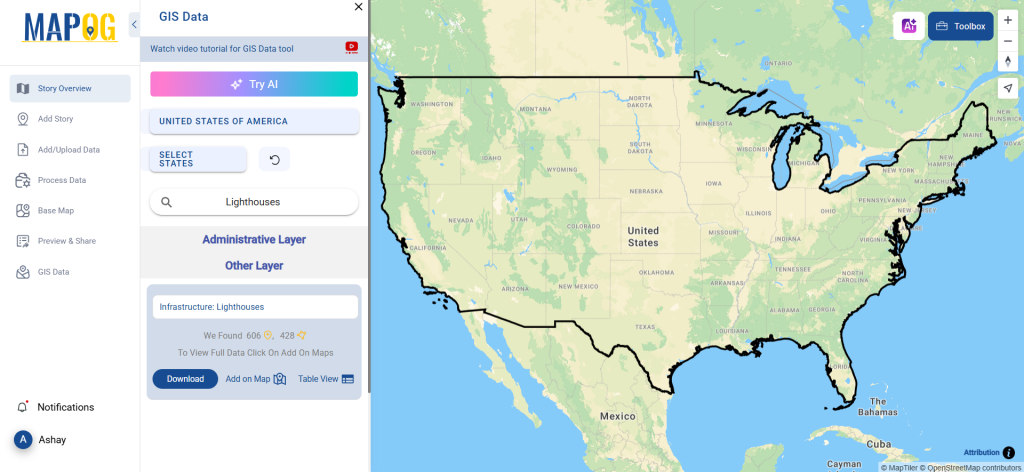
Step 1: Search for Lighthouses Data
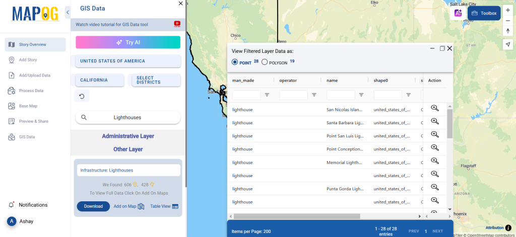
After logging into GIS Data by MAPOG, select the country of interest. Use the Search Layer option to find Lighthouses data. The platform provides both point and polygon data, allowing users to explore attributes such as lighthouse height, year of establishment, and operational status.
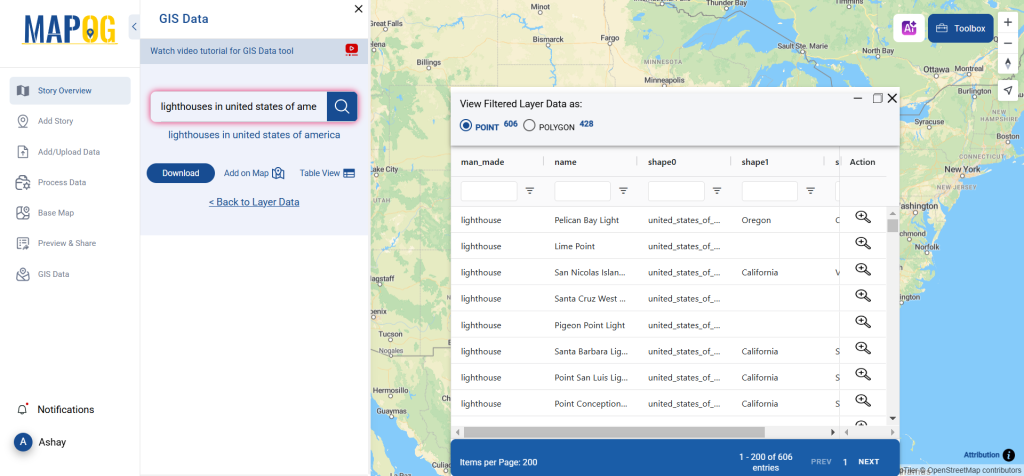
Step 2: Use the AI Search Tool
For faster results, try the “Try AI” feature in the top-left corner. Enter keywords like “Lighthouses Data USA” or “Lighthouses in Canada”, and the AI will fetch the most relevant datasets instantly.
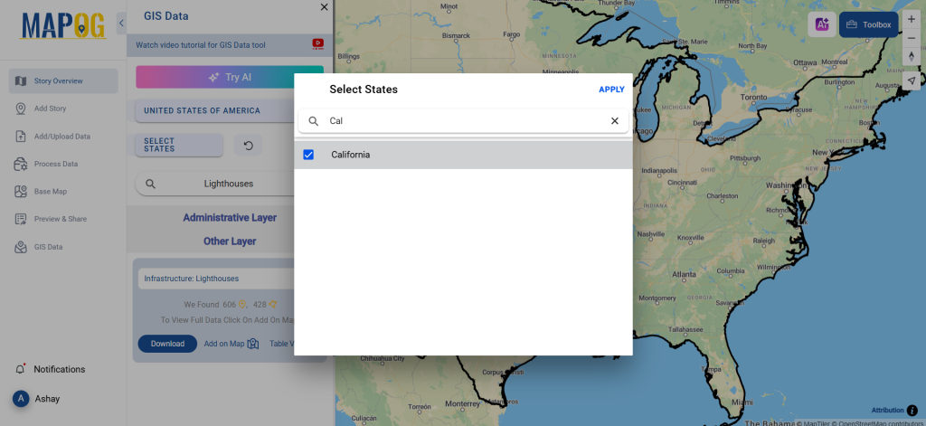
Step 3: Apply Filters
Narrow down your search using the Filter Data option. Users can refine data by state, district, or specific lighthouse categories, ensuring more precise results for their projects.
Step 4: Visualize on the Map
Before downloading, users can preview Lighthouses Data using the “Add on Map” feature. This allows for spatial analysis, making it easier to understand lighthouse distribution and its impact on navigation.
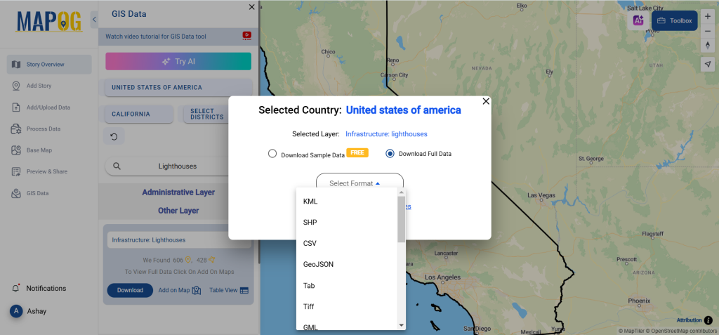
Step 5: Download in Preferred Format
Click on the “Download” button. Users can choose between a sample dataset or a full dataset. Select the desired format, agree to the terms, and finalize the download.
Conclusion
With GIS Data by MAPOG, users can seamlessly download Lighthouses Data in multiple formats for GIS analysis, mapping, and maritime research. The platform provides up-to-date, reliable datasets, making it an essential tool for GIS professionals and researchers. Start exploring today and enhance your GIS projects with precise Lighthouses Data!
With MAPOG’s versatile toolkit, you can effortlessly upload vector and upload Excel or CSV data, incorporate existing layers, perform polyline splitting, use the converter for various formats, calculate isochrones, and utilize the Export Tool.
For any questions or further assistance, feel free to reach out to us at support@mapog.com. We’re here to help you make the most of your GIS data.
Download Shapefile for the following:
- World Countries Shapefile
- Australia
- Argentina
- Austria
- Belgium
- Brazil
- Canada
- Denmark
- Fiji
- Finland
- Germany
- Greece
- India
- Indonesia
- Ireland
- Italy
- Japan
- Kenya
- Lebanon
- Madagascar
- Malaysia
- Mexico
- Mongolia
- Netherlands
- New Zealand
- Nigeria
- Papua New Guinea
- Philippines
- Poland
- Russia
- Singapore
- South Africa
- South Korea
- Spain
- Switzerland
- Tunisia
- United Kingdom Shapefile
- United States of America
- Vietnam
- Croatia
- Chile
- Norway
- Maldives
- Bhutan
- Colombia
- Libya
- Comoros
- Hungary
- Laos
- Estonia
- Iraq
- Portugal
- Azerbaijan
- Macedonia
- Romania
- Peru
- Marshall Islands
- Slovenia
- Nauru
- Guatemala
- El Salvador
- Afghanistan
- Cyprus
- Syria
- Slovakia
- Luxembourg
- Jordan
- Armenia
- Haiti And Dominican Republic
- Malta
- Djibouti
- East Timor
- Micronesia
- Morocco
- Liberia
- Kosovo
- Isle Of Man
- Paraguay
- Tokelau
- Palau
- Ile De Clipperton
- Mauritius
- Equatorial Guinea
- Tonga
- Myanmar
- Thailand
- New Caledonia
- Niger
- Nicaragua
- Pakistan
- Nepal
- Seychelles
- Democratic Republic of the Congo
- China
- Kenya
- Kyrgyzstan
- Bosnia Herzegovina
- Burkina Faso
- Canary Island
- Togo
- Israel And Palestine
- Algeria
- Suriname
- Angola
- Cape Verde
- Liechtenstein
- Taiwan
- Turkmenistan
- Tuvalu
- Ivory Coast
- Moldova
- Somalia
- Belize
- Swaziland
- Solomon Islands
- North Korea
- Sao Tome And Principe
- Guyana
- Serbia
- Senegal And Gambia
- Faroe Islands
- Guernsey Jersey
- Monaco
- Tajikistan
- Pitcairn
Disclaimer : The GIS data provided for download in this article was initially sourced from OpenStreetMap (OSM) and further modified to enhance its usability. Please note that the original data is licensed under the Open Database License (ODbL) by the OpenStreetMap contributors. While modifications have been made to improve the data, any use, redistribution, or modification of this data must comply with the ODbL license terms. For more information on the ODbL, please visit OpenStreetMap’s License Page.
Here are some blogs you might be interested in:
- Download Airport data in Shapefile, KML , MIf +15 GIS format – Filter and download
- Download Bank Data in Shapefile, KML, GeoJSON, and More – Filter and Download
- Download Railway data in Shapefile, KML, GeojSON +15 GIS format
- Download Farmland Data in Shapefile, KML, GeoJSON, and More – Filter and Download
- Download Pharmacy Data in Shapefile, KML, GeoJSON, and More – Filter and Download
- Download ATM Data in Shapefile, KML, MID +15 GIS Formats Using GIS Data by MAPOG
- Download Road Data in Shapefile, KML, GeoJSON, and 15+ GIS Form