
A variety of GIS data formats, including Shapefile, KML, and GPKG, are accessible through the easily navigable GIS Data platform from MAPOG. The software streamlines the process to download lake data and offers users both administrative and geographic data sets. Users can do in-depth mapping and study of lakes worldwide with this program. MAPOG provides a variety of applications and uses for downloading lake data in multiple forms.
MAPOG simplifies lake data downloads with clear guides, offering data for 200+ countries and 900+ layers, compatible with GIS formats like Shapefile, KML, SHP, CSV, GeoJSON, MID.
Download Lake Data of any countries
Note:
- All data is provided in GCS datum EPSG:4326 WGS84 CRS (Coordinate Reference System).
- Users need to log in to access and download their preferred data formats.
Step-by-Step Guide to Download Lake Data
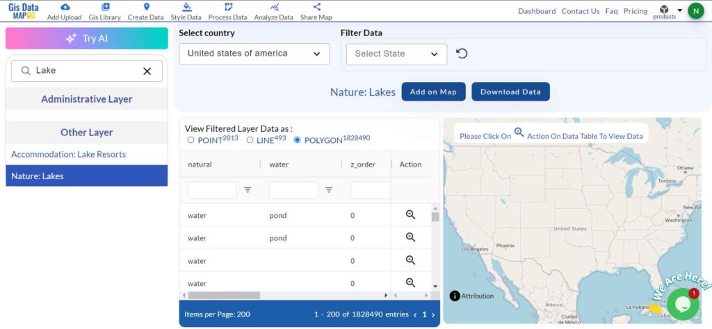
Step 1: Locate ‘Lake Data’
Access the GIS Data interface and select a country of interest. Use the search layer option to find “Lake data.” You can review details like attributes, formats, and whether it is a point or polygon. For instance, search for lakes in different countries like USA, UK and review the data format.
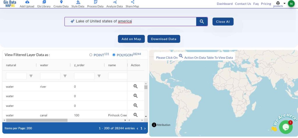
Step 2: Use Try AI Feature Tool
Make use of the “Try AI” tool, found in the upper left corner, to simplify your data search. Input what type of lake data you need and from which area; the AI will quickly provide the relevant datasets.
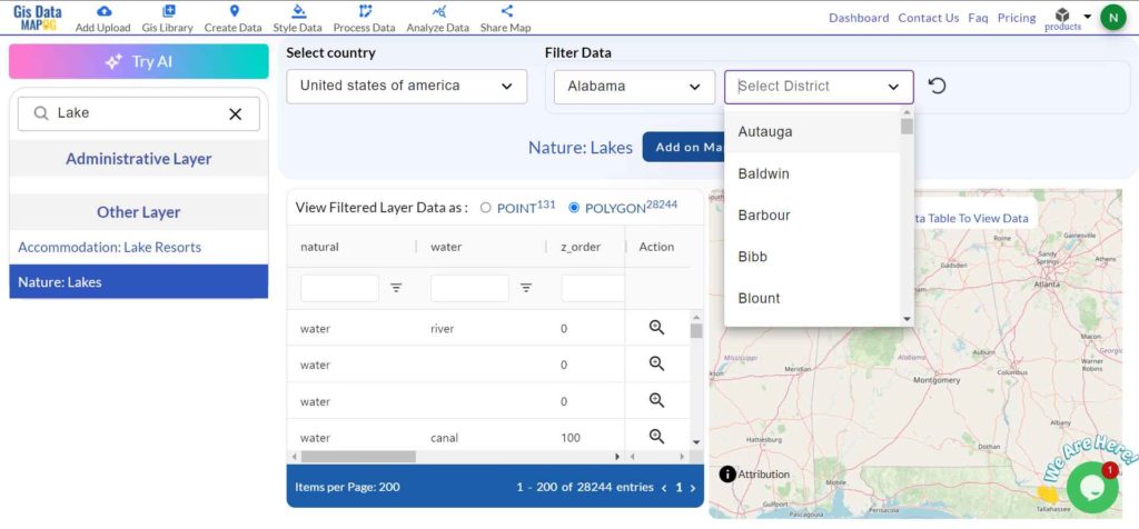
Step 3: Refine Your Search with Filters
To get precise results, use the filter option to narrow down your search by state or district. This feature helps users dive deeper into datasets, focusing on specific areas or details, such as lake boundaries or water levels.
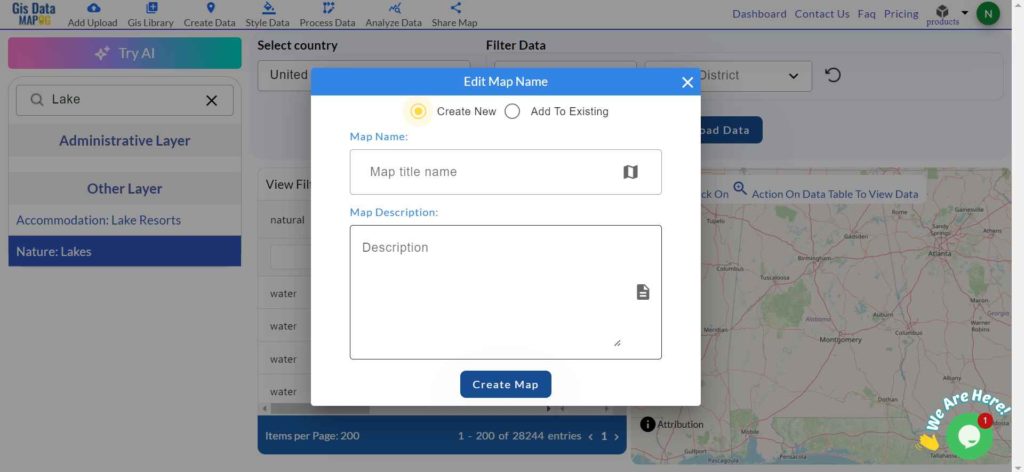
Step 4: Visualize Data with ‘Add on Map’
Select the “Add on Map” feature to overlay the chosen lake data on a map for further analysis in Map analysis. This enables users to visualize spatial relationships and integrate data into new or existing maps, enhancing their GIS projects.
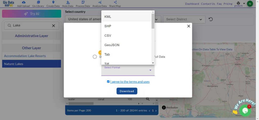
Step 5: Download Your Data
Click on the “Download Data” button. Choose between downloading sample data or the full dataset based on your needs. Select your preferred format—like Shapefile, KML, GeoJSON, or any of the 15+ supported formats. Agree to the terms and conditions, and then click to finalize the download.
Conclusion
MAPOG’s GIS Data platform allows for easy downloading of lake data in multiple GIS formats, providing accurate and current geographic information. It supports a wide range of uses, from environmental research to policy development, making it an essential tool for GIS professionals and enthusiasts.
With MAPOG’s versatile toolkit, you can effortlessly upload vector and raster files, add WMS (Web Map Service) layers, upload Excel or CSV data, incorporate existing files, perform polygon splitting and merging, generate new polygon and polyline data, use the converter for various formats, conduct buffer analysis, create grids, transform points into polygons, calculate isochrones, and utilize the geocoder for precise location information.
For any questions or further assistance, feel free to reach out to us at support@mapog.com. We’re here to help you make the most of your GIS data.
Download Shapefile for the following:
- World Countries Shapefile
- Australia
- Argentina
- Austria
- Belgium
- Brazil
- Canada
- Denmark
- Fiji
- Finland
- Germany
- Greece
- India
- Indonesia
- Ireland
- Italy
- Japan
- Kenya
- Lebanon
- Madagascar
- Malaysia
- Mexico
- Mongolia
- Netherlands
- New Zealand
- Nigeria
- Papua New Guinea
- Philippines
- Poland
- Russia
- Singapore
- South Africa
- South Korea
- Spain
- Switzerland
- Tunisia
- United Kingdom Shapefile
- United States of America
- Vietnam
- Croatia
- Chile
- Norway
- Maldives
- Bhutan
- Colombia
- Libya
- Comoros
- Hungary
- Laos
- Estonia
- Iraq
- Portugal
- Azerbaijan
- Macedonia
- Romania
- Peru
- Marshall Islands
- Slovenia
- Nauru
- Guatemala
- El Salvador
- Afghanistan
- Cyprus
- Syria
- Slovakia
- Luxembourg
- Jordan
- Armenia
- Haiti And Dominican Republic
- Malta
- Djibouti
- East Timor
- Micronesia
- Morocco
- Liberia
- Kosovo
- Isle Of Man
- Paraguay
- Tokelau
- Palau
- Ile De Clipperton
- Mauritius
- Equatorial Guinea
- Tonga
- Myanmar
- Thailand
- New Caledonia
- Niger
- Nicaragua
- Pakistan
- Nepal
- Seychelles
- Democratic Republic of the Congo
- China
- Kenya
- Kyrgyzstan
- Bosnia Herzegovina
- Burkina Faso
- Canary Island
- Togo
- Israel And Palestine
- Algeria
- Suriname
- Angola
- Cape Verde
- Liechtenstein
- Taiwan
- Turkmenistan
- Tuvalu
- Ivory Coast
- Moldova
- Somalia
- Belize
- Swaziland
- Solomon Islands
- North Korea
- Sao Tome And Principe
- Guyana
- Serbia
- Senegal And Gambia
- Faroe Islands
- Guernsey Jersey
- Monaco
- Tajikistan
- Pitcairn
Disclaimer : The GIS data provided for download in this article was initially sourced from OpenStreetMap (OSM) and further modified to enhance its usability. Please note that the original data is licensed under the Open Database License (ODbL) by the OpenStreetMap contributors. While modifications have been made to improve the data, any use, redistribution, or modification of this data must comply with the ODbL license terms. For more information on the ODbL, please visit OpenStreetMap’s License Page.