GIS Data by MAPOG is a user-friendly platform that allows users to download fitness centre data in multiple GIS formats, including Shapefile, KML, GeoJSON, and more. This tool provides access to detailed administrative and geographic datasets, enabling users to create accurate maps for fitness centres worldwide.
Why Fitness Centre Data is Important?
Fitness centre data is essential for multiple applications, such as health and wellness research, market analysis, urban planning, and location-based services. With GIS Data by MAPOG, users can access up-to-date datasets on gyms, health clubs, and wellness centers across various regions.
Download Fitness Centre Data of any countries
Note:
- All data is provided in GCS datum EPSG:4326 WGS84 CRS (Coordinate Reference System).
- Users need to log in to access and download their preferred data formats.
Step-by-Step Guide to Download Fitness Centre Data
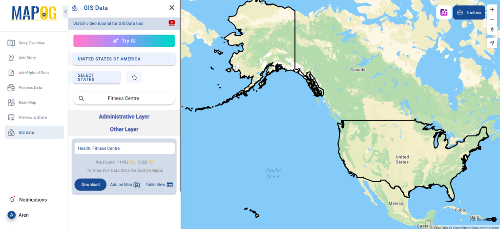
Step 1: Search for Fitness Centre Data
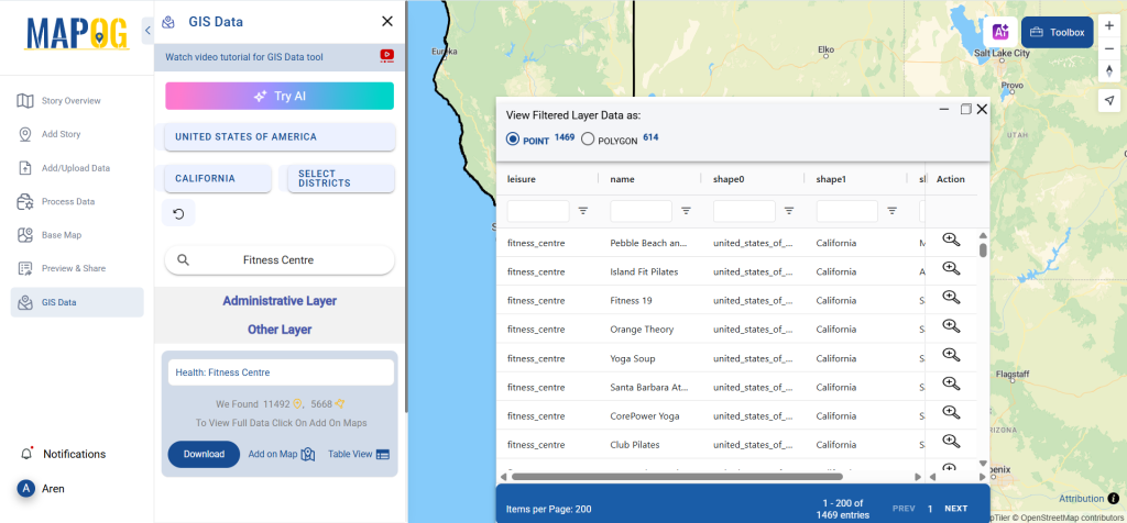
Log in to GIS Data by MAPOG and navigate to the search layer option. Enter “Fitness Centre Data“ along with the desired country. The system will display relevant datasets, categorized by points or polygons. Users can refine their search based on specific attributes.
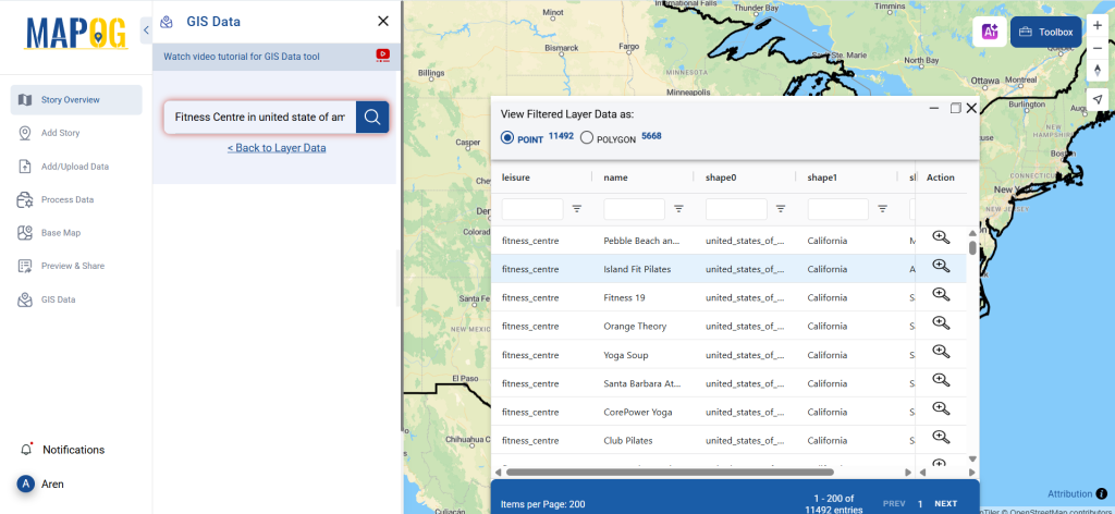
Step 2: Use the AI Feature for Quick Search
Take advantage of MAPOG’s Try AI tool, located in the top-left corner. Simply type your required data type and location, and the AI will generate the most relevant results instantly.
Step 3: Apply Filters for Better Accuracy
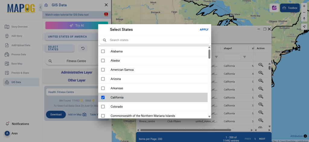
Refine your search further by using the Filter Data option. Narrow down results based on city, district, or state, making it easier to analyze specific regions. This feature is useful for business owners and analysts looking for high-density fitness center locations.
Step 4: Visualize Data on a Map
Click “Add on Map” to overlay fitness centre data onto a visual GIS mapping interface. This step enhances spatial analysis by providing insights into location distribution, accessibility, and more.
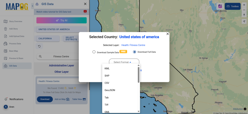
Step 5: Download in Your Preferred Format
Click on the “Download Data” button. Choose between a sample file or the full dataset. Select from over 15 supported GIS formats, including Shapefile, KML, GeoJSON, MID, and more. Agree to the terms, then click the final download button to get your fitness center data.
Final Thoughts
Using GIS Data by MAPOG, users can seamlessly download fitness centre data for research, business, and planning needs. With a variety of formats, powerful search tools, and mapping capabilities, MAPOG stands out as a top-tier platform for GIS data extraction.
With MAPOG’s versatile toolkit, you can effortlessly upload vector and upload Excel or CSV data, incorporate existing layers, perform polyline splitting, use the converter for various formats, calculate isochrones, and utilize the Export Tool.
For any questions or further assistance, feel free to reach out to us at support@mapog.com. We’re here to help you make the most of your GIS data.
Download Shapefile for the following:
- World Countries Shapefile
- Australia
- Argentina
- Austria
- Belgium
- Brazil
- Canada
- Denmark
- Fiji
- Finland
- Germany
- Greece
- India
- Indonesia
- Ireland
- Italy
- Japan
- Kenya
- Lebanon
- Madagascar
- Malaysia
- Mexico
- Mongolia
- Netherlands
- New Zealand
- Nigeria
- Papua New Guinea
- Philippines
- Poland
- Russia
- Singapore
- South Africa
- South Korea
- Spain
- Switzerland
- Tunisia
- United Kingdom Shapefile
- United States of America
- Vietnam
- Croatia
- Chile
- Norway
- Maldives
- Bhutan
- Colombia
- Libya
- Comoros
- Hungary
- Laos
- Estonia
- Iraq
- Portugal
- Azerbaijan
- Macedonia
- Romania
- Peru
- Marshall Islands
- Slovenia
- Nauru
- Guatemala
- El Salvador
- Afghanistan
- Cyprus
- Syria
- Slovakia
- Luxembourg
- Jordan
- Armenia
- Haiti And Dominican Republic
- Malta
- Djibouti
- East Timor
- Micronesia
- Morocco
- Liberia
- Kosovo
- Isle Of Man
- Paraguay
- Tokelau
- Palau
- Ile De Clipperton
- Mauritius
- Equatorial Guinea
- Tonga
- Myanmar
- Thailand
- New Caledonia
- Niger
- Nicaragua
- Pakistan
- Nepal
- Seychelles
- Democratic Republic of the Congo
- China
- Kenya
- Kyrgyzstan
- Bosnia Herzegovina
- Burkina Faso
- Canary Island
- Togo
- Israel And Palestine
- Algeria
- Suriname
- Angola
- Cape Verde
- Liechtenstein
- Taiwan
- Turkmenistan
- Tuvalu
- Ivory Coast
- Moldova
- Somalia
- Belize
- Swaziland
- Solomon Islands
- North Korea
- Sao Tome And Principe
- Guyana
- Serbia
- Senegal And Gambia
- Faroe Islands
- Guernsey Jersey
- Monaco
- Tajikistan
- Pitcairn
Disclaimer : The GIS data provided for download in this article was initially sourced from OpenStreetMap (OSM) and further modified to enhance its usability. Please note that the original data is licensed under the Open Database License (ODbL) by the OpenStreetMap contributors. While modifications have been made to improve the data, any use, redistribution, or modification of this data must comply with the ODbL license terms. For more information on the ODbL, please visit OpenStreetMap’s License Page.
Here are some blogs you might be interested in:
- Download Airport data in Shapefile, KML , MIf +15 GIS format – Filter and download
- Download Bank Data in Shapefile, KML, GeoJSON, and More – Filter and Download
- Download Railway data in Shapefile, KML, GeojSON +15 GIS format
- Download Farmland Data in Shapefile, KML, GeoJSON, and More – Filter and Download
- Download Pharmacy Data in Shapefile, KML, GeoJSON, and More – Filter and Download
- Download ATM Data in Shapefile, KML, MID +15 GIS Formats Using GIS Data by MAPOG
- Download Road Data in Shapefile, KML, GeoJSON, and 15+ GIS Form