GIS Data by MAPOG is an efficient platform for accessing GIS data in formats like Shapefile, KML, GeoJSON, and many others. It provides a seamless interface to Download Arts Centre Data, allowing users to explore, analyze, and map arts centres globally. Whether you’re a planner, researcher, or GIS enthusiast, this tool simplifies the process of acquiring relevant geographic datasets.
What is Arts Centre Data?
Arts Centre Data focuses on locations dedicated to promoting culture, including museums, galleries, theaters, and performance spaces. These datasets are essential for urban planning, tourism, and cultural resource management.
Key Features of MAPOG GIS Data
- Offers over 900 layers across 200+ countries.
- Supports multiple formats, including SHP, KML, GeoJSON, MIF, and GPS.
Download Arts Centre data of any countries
Note:
- All data is provided in GCS datum EPSG:4326 WGS84 CRS (Coordinate Reference System).
- Users need to log in to access and download their preferred data formats.
Step-by-Step Guide to Download Arts Centre Data
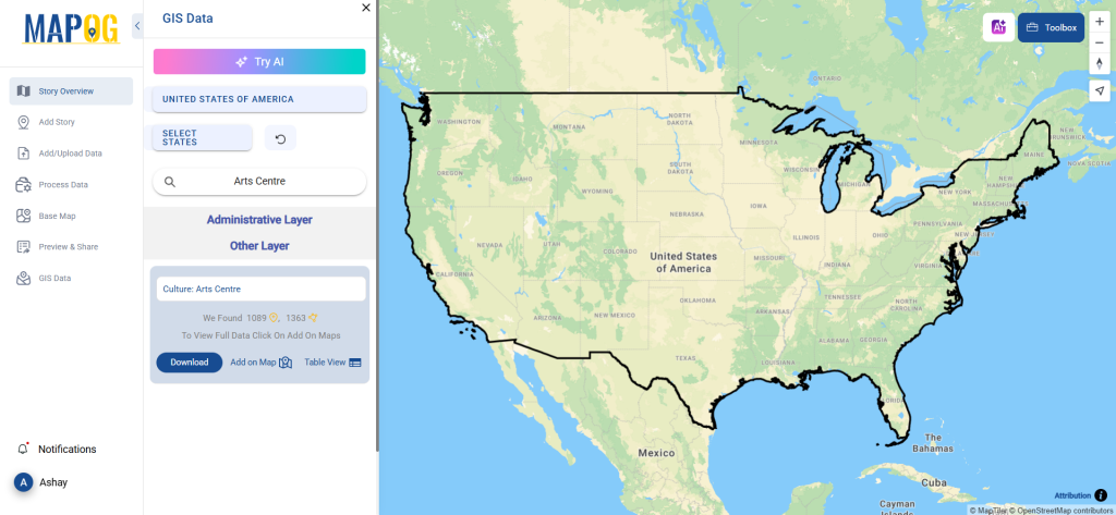
Step 1: Locate Arts Centre Data
Log in to MAPOG and access the GIS Data section. Use the search bar to find “Arts Centre” data. Select the desired country and examine the attributes, including format (point or polygon) and available details.
Step 2: Use the AI Search Tool
Simplify your search with the “Try AI” tool. Type what you need, such as “Arts Centre Data in urban areas,” and the system will quickly deliver the relevant results.

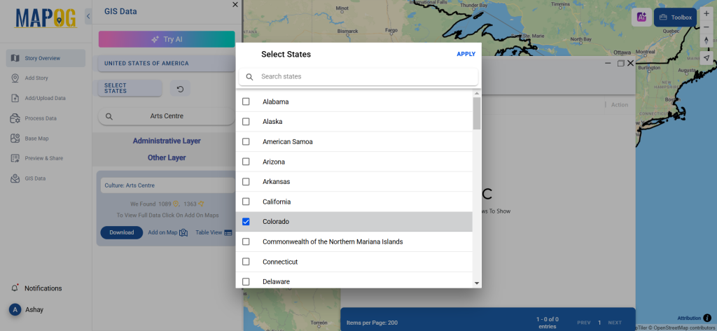
Step 3: Refine Your Search
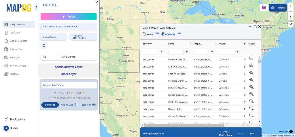
Narrow down your results using the filter feature. Focus on specific regions, states, or cities to locate arts centres in a particular area. This ensures precise and relevant data for your analysis.
Step 4: Add Data to the Map
Use the “Add on Map” option to overlay the Arts Centre Data on your map. You can add it to an existing map or create a new one. This feature provides insights into spatial relationships and trends.
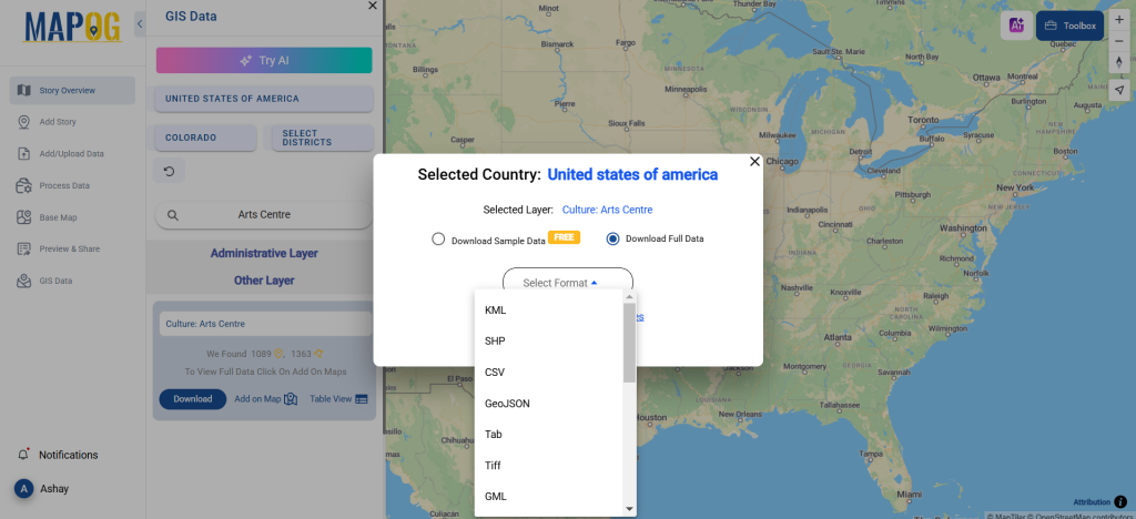
Step 5: Download Arts Centre Data
Click the “Download Data” button. Choose between sample and full datasets based on your requirements. Select your preferred format—Shapefile, KML, MID, or any of the 15+ supported formats. Accept the terms and click to download.
Conclusion
MAPOG’s GIS Data simplifies the process to Download Arts Centre Data for mapping, analysis, or research purposes. With a wide variety of formats and user-friendly tools, it ensures easy access to valuable geographic information. Start exploring today and bring your GIS projects to life!
With MAPOG’s versatile toolkit, you can effortlessly upload vector and upload Excel or CSV data, incorporate existing layers, perform polyline splitting, use the converter for various formats, calculate isochrones, and utilize the Export Tool.
For any questions or further assistance, feel free to reach out to us at support@mapog.com. We’re here to help you make the most of your GIS data.
Download Shapefile for the following:
- World Countries Shapefile
- Australia
- Argentina
- Austria
- Belgium
- Brazil
- Canada
- Denmark
- Fiji
- Finland
- Germany
- Greece
- India
- Indonesia
- Ireland
- Italy
- Japan
- Kenya
- Lebanon
- Madagascar
- Malaysia
- Mexico
- Mongolia
- Netherlands
- New Zealand
- Nigeria
- Papua New Guinea
- Philippines
- Poland
- Russia
- Singapore
- South Africa
- South Korea
- Spain
- Switzerland
- Tunisia
- United Kingdom Shapefile
- United States of America
- Vietnam
- Croatia
- Chile
- Norway
- Maldives
- Bhutan
- Colombia
- Libya
- Comoros
- Hungary
- Laos
- Estonia
- Iraq
- Portugal
- Azerbaijan
- Macedonia
- Romania
- Peru
- Marshall Islands
- Slovenia
- Nauru
- Guatemala
- El Salvador
- Afghanistan
- Cyprus
- Syria
- Slovakia
- Luxembourg
- Jordan
- Armenia
- Haiti And Dominican Republic
- Malta
- Djibouti
- East Timor
- Micronesia
- Morocco
- Liberia
- Kosovo
- Isle Of Man
- Paraguay
- Tokelau
- Palau
- Ile De Clipperton
- Mauritius
- Equatorial Guinea
- Tonga
- Myanmar
- Thailand
- New Caledonia
- Niger
- Nicaragua
- Pakistan
- Nepal
- Seychelles
- Democratic Republic of the Congo
- China
- Kenya
- Kyrgyzstan
- Bosnia Herzegovina
- Burkina Faso
- Canary Island
- Togo
- Israel And Palestine
- Algeria
- Suriname
- Angola
- Cape Verde
- Liechtenstein
- Taiwan
- Turkmenistan
- Tuvalu
- Ivory Coast
- Moldova
- Somalia
- Belize
- Swaziland
- Solomon Islands
- North Korea
- Sao Tome And Principe
- Guyana
- Serbia
- Senegal And Gambia
- Faroe Islands
- Guernsey Jersey
- Monaco
- Tajikistan
- Pitcairn
Disclaimer : The GIS data provided for download in this article was initially sourced from OpenStreetMap (OSM) and further modified to enhance its usability. Please note that the original data is licensed under the Open Database License (ODbL) by the OpenStreetMap contributors. While modifications have been made to improve the data, any use, redistribution, or modification of this data must comply with the ODbL license terms. For more information on the ODbL, please visit OpenStreetMap’s License Page.
Here are some blogs you might be interested in:
- Download Airport data in Shapefile, KML , MIf +15 GIS format – Filter and download
- Download Bank Data in Shapefile, KML, GeoJSON, and More – Filter and Download
- Download Railway data in Shapefile, KML, GeojSON +15 GIS format
- Download Farmland Data in Shapefile, KML, GeoJSON, and More – Filter and Download
- Download Pharmacy Data in Shapefile, KML, GeoJSON, and More – Filter and Download
- Download ATM Data in Shapefile, KML, MID +15 GIS Formats Using GIS Data by MAPOG
- Download Road Data in Shapefile, KML, GeoJSON, and 15+ GIS Form