Merge more than two Shapefile in QGIS. Do you want to merge two or more than two Shapefile? Do all the Shapefile are of same shape type i.e the Shapefile which can be merged with each other should have an identical shape, i.e either “Point”, “Line” or “Polygon”? Do Shapefile all 3 files i.e .shx, .shp and .dbf are available? Then let us move to QGIS (Quantum GIS), an Open source Geographic information SystemSoftware. If not installed in your system, one of the way to install QGIS, with OSGeo4W provides or either you can install QGIS with standalone software. Let us move to Merge more than two Shapefile:
1.) Take and copy all Shapefiles to a common folder which you want to merge.
2.) Open up QGIS desktop and select the following from the menu :
Vector -> Data Management tools -> merge shapefile to one, which will open up new window “Merge Shapefiles”, as shown below.
3.) Now select the browse input directory to the folder you created which include all Shapefile that you need to copy. Also browse the Output directory for getting the new merged Shapefile, and name the output file, as shown below:
4.) Press Ok. It will process your all shapefile and merge it to one. Finished.
Note: New .dbf file will contain sum of column of two shapfefile minus common column.
Here you can see the output of two merged Shapefile of Road and Rail Route of India.
1.)Road Shapefile of india
2.) Rail Route Shapefile
3.) Final Output : Merged Shapefile :
Hope this helps you to merge two or more shapefile with the help of QGIS tool. You can also find QGIS operation to convert Shapefile to GeoJSON, convert kml to Shapefile and Shapefile to KML. If you find any problem on implementing the above steps do comment below. Your suggestions are always welcome as comment.
Pan-sharpening images using ArcGIS. Pansharpening is the process which makes use of panchromatic image and some bands of multispectral image to result in a high resolution image. Pansharpening stands for panchromatic sharpening. Here sharpening basic refers to increase the spatial resolution of multisprectral image or color image. This technique of increasing resolution has been used by various organisations that provide satellite imagery of high resolution like Google images etc.
A multi spectral image is captured with high spectral resolution as it is displayed in different colors while the panachromatic image is captured with high spatial resolution and provides a cluster of red, green and blue pixels resulting in a gray scale image.Now the question is how we get a pan-sharpened image? The possible answer by an ArcGIS user can be it’s just a tool to run. But is it that easy? No. Both the images has to be pre-processed before applying this tool which comes out to be a tough process if you have a number of tiles for your area of interest.
Pan-sharpening images using ArcGIS
First of all start with the multispectral image let’s say a cartosat image with a resolution of 1 arc sec. Start with stacking of different bands(either all even or all odd number) in Erdas imagine. Perform Geo-referencing of each tile making one tile static.
Then mosaicing of tiles in ArcGIS using Mosaic tool of data management tool set. The panchromatic image will be a single band image say panchromatic band of lansat image with 15 m resolution so it does not need to be stacked. So just mosaic all the tiles of panchromatic image. Geo-reference both multispectral and panchromatic image accordingly so that they both are same spatial location without any spatial difference.
Now apply tool create pan-sharpened raster data-set of data management tool-set.
Thus a multispectral image with high spatial resolution is obtained. As panchromatic image possess high spatial information and multispectral image possess good color information. Fusion of the two brings out a colored image of high resolution which can be used as a product for any client who want an detailed view of his area of interest.
c++ program to read shapefile header. Shapefile can be read if you know the format of Shapefile files i.e of .shp, .shx, and .dbf file. ESRI provided technical description of the Shapefile files which describes very clearly about the format of storage of data in all three formats i.e .shp, .shx and .dbf. You can also interpret and take the advantage to make simple GIS tool which can read and edit Shapefile properly. Here is the link of the Shapefile technical descrption : ESRI Technical Discription. This program reads only Shapefile .shp header, which includes file code, length, version, bounding box coordinates and the type of shape Shapefile you loaded. You can also find simple program that just reads about bounding box of that shapefile. The code is explained with the comments provided in all function that you found.
c++ program to read shapefile header:
#include<iostream>
#include<stdio.h>
#include<conio.h>
usingnamespace std;
class ByteConverter
{
public:
//Convert 32 bits which is stored in BigEndian format to integer. This is performed with the help of bit operation i.e left shifting and operating or.
staticint32_t bigEndianIntRead(char *fileBuf, int startIndex)
{
return (((fileBuf[startIndex + 0] & 0xff) << 24) | ((fileBuf[ + 1] & 0xff) << 16)| ((fileBuf[startIndex + 2] & 0xff) << 8) | ((fileBuf[startIndex + 3] & 0xff)));
}
//Convert 32 bits which is stored in BigEndian format to integer. This is performed with the help of bit operation i.e left shifting and operating or.
staticint32_t littleEndianIntRead(char *fileBuf, int startIndex)
{
return (((fileBuf[startIndex + 3] & 0xff) << 24) | ((fileBuf[startIndex + 2] & 0xff) << 16) | ((fileBuf[startIndex + 1] & 0xff) << 8) | ((fileBuf[startIndex + 0] & 0xff)));
}
//Convert 64 bits or 8 Byte which is stored in BigEndian format to integer. This is performed with the help of bit operation i.e left shifting and operating or.
staticdouble littleEndianDoubleRead(char *fileBuf,int startIndex)
{
double convert;
char *add;
int j;
add = newchar();
j=-1;
for(int i=startIndex; i<startIndex+8; i++)
{
j++;
add[j] = fileBuf[i];
}
convert = *reinterpret_cast<double * const>(add);
return convert;
}
};
//Class HeaderShapefile have all funtion implemented to desribe every field of shapefile header file.
class HeaderShapefile
{
public:
//filecode describes the code of .shp file. As described in Shapefile Technical description of ESRI, filecode
//value is always constant and should have 9994 value.
staticint32_t fileCode(char*fileBuf, int startIndex)
{
return ByteConverter::bigEndianIntRead(fileBuf,startIndex);
}
//File length contains Length of the file field
staticint32_t fileLength(char*fileBuf, int startIndex)
{
return ByteConverter::bigEndianIntRead(fileBuf,startIndex);
}
//Version function
staticint32_t version(char*fileBuf, int startIndex)
{
return ByteConverter::littleEndianIntRead(fileBuf,startIndex);
}
//Function shapeType describes the type of the shape. It returns an 32 bit integer
//value. This integer is then matched with the cooresponding shape as described in ESRI shapefile pdf
staticint32_t shapeType(char*fileBuf, int startIndex)
{
return ByteConverter::littleEndianIntRead(fileBuf,startIndex);
}
//This remaning funtion of the class will calculate the bounding box coordinates of the shapefile.
//Following values i.e x and y minimum and maximum values also with z and m minimum
// and maximum values are obtained.
staticdouble dimensionXMin(char*fileBuf, int startIndex)
{
return ByteConverter::littleEndianDoubleRead(fileBuf,startIndex);
}
staticdouble dimensionYmin(char*fileBuf, int startIndex)
{
return ByteConverter::littleEndianDoubleRead(fileBuf, startIndex);
}
staticdouble dimensionXmax(char*fileBuf, int startIndex)
{
return ByteConverter::littleEndianDoubleRead(fileBuf, startIndex);
}
staticdouble dimensionYmax(char*fileBuf, int startIndex)
{
return ByteConverter::littleEndianDoubleRead(fileBuf, startIndex);
}
staticdouble dimensionZmin(char*fileBuf, int startIndex)
{
return ByteConverter::littleEndianDoubleRead(fileBuf, startIndex);
}
staticdouble dimensionZmax(char*fileBuf, int startIndex)
{
return ByteConverter::littleEndianDoubleRead(fileBuf, startIndex);
}
staticdouble dimensionMmin(char*fileBuf, int startIndex)
{
return ByteConverter::littleEndianDoubleRead(fileBuf, startIndex);
}
staticdouble dimensionMmax(char*fileBuf, int startIndex)
{
return ByteConverter::littleEndianDoubleRead(fileBuf, startIndex);
}
};
class SizeOfFile
{
public:
//This function finds the size of file in Byte
staticlong sizeOfFiles(FILE *file)
{
long l, e;
l = ftell(file);
fseek(file, 0, 2);
e = ftell(file);
fseek(file, l, 0);
return e;
}
};
int main()
{
int32_t filecodes, fileLengths, shapeTypes, versions;
double xmin, ymin, xmax, ymax, mmin, mmax, zmin, zmax;
string shape;
char *filePath = "map.shp";
char*fileBuf; // Pointer to our buffered data
FILE *file = NULL; // File pointer
// Open the file in binary mode using the "rb" format string
// This also checks if the file exists and/or can be opened for reading correctly
if ((file = fopen(filePath, "rb")) == NULL)
cout << "Could not open specified file" << endl;
else
cout << "File opened successfully" << endl;
// Get the size of the file in bytes
long fileSize = SizeOfFile::sizeOfFiles(file);
// Allocate space in the buffer for the whole file
fileBuf = newchar[fileSize];
// Read the file in to the buffer
fread(fileBuf, fileSize, 1, file);
// Now that we have the entire file buffered, we can take a look at some binary infomation
cout<<"File size = " <<fileSize;
cout<<"File size get = "<<fileBuf;
filecodes = HeaderShapefile::fileCode(fileBuf,0);
fileLengths = HeaderShapefile::fileLength(fileBuf,24);
versions = HeaderShapefile::version(fileBuf,28);
shapeTypes = HeaderShapefile::shapeType(fileBuf,32);
xmin = HeaderShapefile::dimensionXMin(fileBuf,36);
ymin = HeaderShapefile::dimensionYmin(fileBuf,44);
xmax = HeaderShapefile::dimensionXmax(fileBuf,52);
ymax = HeaderShapefile::dimensionYmax(fileBuf,60);
zmin = HeaderShapefile::dimensionZmin(fileBuf,68);
zmax = HeaderShapefile::dimensionZmax(fileBuf,76);
mmin = HeaderShapefile::dimensionMmin(fileBuf,84);
mmax = HeaderShapefile::dimensionMmax(fileBuf,92);
/*****************HEADER SHAPEFILE DETAIL*********************/
cout<<endl<<"/*****************HEADER SHAPEFILE DETAIL*********************/";
cout<<endl<<"File code = "<<filecodes<<endl;
cout<<"File Length = "<<fileLengths<<endl;
cout<<"Version = "<<versions<<endl;
//This shapefile shapetypes can be found in the technical discription.
switch(shapeTypes)
{
case0:
shape = "Null Shape";
break;
case1:
shape = "Point";
break;
case3:
shape = "Poly Line";
break;
case5:
shape = "Polygon";
break;
case8:
shape = "MultiPoint";
break;
case11:
shape = "PointZ";
break;
case13:
shape = "PolyLineZ";
break;
case15:
shape = "PolygonZ";
break;
case18:
shape = "MultiPointZ";
break;
case21:
shape = "PointM";
break;
case23:
shape = "PolyLineM";
break;
case25:
shape = "PolygonM";
break;
case28:
shape = "MultiPointM";
break;
case31:
shape = "MultiPatch";
break;
default:
shape = "Wrong match found";
break;
}
cout<<"Shape Type = "<<shape<<endl;
cout<<endl<<"************* Bounding Box **************"<<endl;
cout<<"X minimum = "<<xmin<<endl;
cout<<"Y minimum = "<<ymin<<endl;
cout<<"X maximum = "<<xmax<<endl;
cout<<"Y maximum = "<<ymax<<endl;
cout<<"Z minimum = "<<zmin<<endl;
cout<<"Z maximum = "<<zmax<<endl;
cout<<"M minimum = "<<mmin<<endl;
cout<<"M maximum = "<<mmax<<endl;
cin.get();
delete[]fileBuf;
fclose(file); // Almost forgot this
return0;
}
Get minimum Bounding box of shapefile c++ program. This program not only reads shapefile, but makes you aware to read other files, i.e files which have .dbf, .exe, .png etc format without having software. Before that you should know about bits, byte order, and conversion of bytes to other data types and most importantly the format of the files that you want to read.
A shapefile stores non topological geometry. ESRI shapfile mainly contains 3 files, i.e .shp, .shx and .dbf files. To get bounding box details of shapefile, we need to concern about .shp file format. You can find all the technical discription of shapefile, provided by esri in their website.
Shapefile .shp has 3 parts, i.e file header, record header and record contents. File header stores the bounding box of shapefile. You can also see c++ program to read shapefile header. Here is the program:
Get minimum Bounding box of shapefile c++ program
#include<iostream>
#include<stdio.h>
#include<conio.h>
usingnamespace std;
class ByteConverter
{
public:
//Convert 32 bits which is stored in BigEndian format to integer. This is performed with the help of bit operation i.e left shifting and operating or.
staticint32_t bigEndianIntRead(char *fileBuf, int startIndex)
{
return (((fileBuf[startIndex + 0] & 0xff) << 24) | ((fileBuf[ + 1] & 0xff) << 16)| ((fileBuf[startIndex + 2] & 0xff) << 8) | ((fileBuf[startIndex + 3] & 0xff)));
}
//Convert 32 bits which is stored in BigEndian format to integer. This is performed with the help of bit operation i.e left shifting and operating or.
staticint32_t littleEndianIntRead(char *fileBuf, int startIndex)
{
return (((fileBuf[startIndex + 3] & 0xff) << 24) | ((fileBuf[startIndex + 2] & 0xff) << 16) | ((fileBuf[startIndex + 1] & 0xff) << 8) | ((fileBuf[startIndex + 0] & 0xff)));
}
//Convert 64 bits or 8 Byte which is stored in BigEndian format to integer. This is performed with the help of bit operation i.e left shifting and operating or.
staticdouble littleEndianDoubleRead(char *fileBuf,int startIndex)
{
double convert;
char *add;
int j;
add = newchar();
j=-1;
for(int i=startIndex; i<startIndex+8; i++)
{
j++;
add[j] = fileBuf[i];
}
convert = *reinterpret_cast<double * const>(add);
return convert;
}
};
//Class HeaderShapefile have all funtion implemented to desribe every field of shapefile header file.
class HeaderShapefile
{
public:
//This funtion of the class will calculate the bounding box coordinates of the shapefile.
//Following values i.e x and y minimum and maximum values also with z and m minimum
// and maximum values are obtained.
staticdouble dimensionXMin(char*fileBuf, int startIndex)
{
return ByteConverter::littleEndianDoubleRead(fileBuf,startIndex);
}
staticdouble dimensionYmin(char*fileBuf, int startIndex)
{
return ByteConverter::littleEndianDoubleRead(fileBuf, startIndex);
}
staticdouble dimensionXmax(char*fileBuf, int startIndex)
{
return ByteConverter::littleEndianDoubleRead(fileBuf, startIndex);
}
staticdouble dimensionYmax(char*fileBuf, int startIndex)
{
return ByteConverter::littleEndianDoubleRead(fileBuf, startIndex);
}
};
class SizeOfFile
{
public:
//This function finds the size of file in Byte
staticlong sizeOfFiles(FILE *file)
{
long l, e;
l = ftell(file);
fseek(file, 0, 2);
e = ftell(file);
fseek(file, l, 0);
return e;
}
};
int main()
{
int32_t filecodes, fileLengths, shapeTypes, versions;
double xmin, ymin, xmax, ymax, mmin, mmax, zmin, zmax;
string shape;
char *filePath = "map.shp";
char*fileBuf; // Pointer to our buffered data
FILE *file = NULL; // File pointer
// Open the file in binary mode using the "rb" format string
// This also checks if the file exists and/or can be opened for reading correctly
if ((file = fopen(filePath, "rb")) == NULL)
cout << "Could not open specified file" << endl;
else
cout << "File opened successfully" << endl;
// Get the size of the file in bytes
long fileSize = SizeOfFile::sizeOfFiles(file);
// Allocate space in the buffer for the whole file
fileBuf = newchar[fileSize];
// Read the file in to the buffer
fread(fileBuf, fileSize, 1, file);
// Now that we have the entire file buffered, we can take a look at some binary infomation
cout<<"File size = " <<fileSize;
xmin = HeaderShapefile::dimensionXMin(fileBuf,36);
ymin = HeaderShapefile::dimensionYmin(fileBuf,44);
xmax = HeaderShapefile::dimensionXmax(fileBuf,52);
ymax = HeaderShapefile::dimensionYmax(fileBuf,60);
/*****************MINIMUM BOUNDING BOX OF SHAPEFILE DETAIL*********************/
cout<<endl<<"\n/*****************MINIMUM BOUNDING BOX SHAPEFILE DETAIL*********************/\n\n";
cout<<"X minimum = "<<xmin<<endl;
cout<<"Y minimum = "<<ymin<<endl;
cout<<"X maximum = "<<xmax<<endl;
cout<<"Y maximum = "<<ymax<<endl;
cin.get();
delete[]fileBuf;
fclose(file); // Almost forgot this
return0;
}
Output of Get minimum Bounding box of shapefile c++ program
What is GIS | Geographic Information System? GIS is an Abbreviation of Geographical Information System or Geo-spatial Information Systems or Geologic Information Systems (also Geo-spatial database management). As the name suggest ‘GIS’ is related to geographical information. But before explaining what is GIS?, we should know about what Geographic information means? Geographic information is knowledge of where something is. It defines the spatial reference of the element or matter present on earth surface.
As it is said “a picture is worth a thousand words”, Maps plays a lead role in defining geographical information. We control map to guide someone to know the actual route, exact destination, its distance, its elevation, its surroundings etc. Geographical information is needed to Government, Industries, Business markets, Tourism and services sector, Education, Agriculture, Health, Disaster Management, Transportation and also to a common people. It makes us easy to locate an area of industries, day care center, restaurant, mall, head quarter or any other specific place. It solves everyday issues. What is the shortest route to get to work? How can i get to hotel? Where is the location of my new office? So, Geographical information is part of our lives. But how can we get geographic information and What is GIS?
What is GIS | Geographic Information System?
GIS is a tool to acquire geographic data and produce Geographic information. Generally Information about those features are stored in tabular form. GIS can be defined as a “computer information system that can input, store, manipulate, analyze, and display geographically referenced (spatial) data to support decision making processes”.
GIS enables us to connect dynamic relations between spatial data (geo referenced) & relational data (attribute of features in tabular forms). It enable us to make models of reality, of the ground and to answer question such as what is where? Main component of Geographic information system are: Hardware, Software, Data and People.
Some organizations defined GIS – Geographical Information System as :
A geographic information system (GIS) is a computer-based tool for mapping and analyzing things that exist and events that happen on earth. GIS technology integrates common database operations such as query and statistical analysis with the unique visualization and geographic analysis benefits offered by maps.” ~ ESRI
“GIS is an integrated system of computer hardware, software, and trained personnel linking topographic, demographic, utility, facility, image and other resource data that is geographically referenced.” ~ NASA
Google Map can be considered as an Example of GIS tool. You can have a look over 35+ Google Tips and tricks.
The demand for GIS tools is continuously growing. One of such tool is QGIS(Quantum GIS), and is a cross platform, free open source desktop application. From a citizen to an organization, every body needs Geographic information. You can find here advantage of GIS and Why GIS. I hope that reading this post will make you to learn more about Geographic information System. I would appreciate your comment, if you like to share more ideas related to the same topic.
Convert Shapefile to kml by QGIS. Shapefile is ESRI based Vector file, While KML or Keyhole Markup Language is file which models and stores geographic features for display in Google Earth or Google maps. Many times you may require to convert the required shapefile to KML file, so that you can deploy the same over Google Earth for some reason. QGIS (Quantum GIS) is an open source GIS (Geographic Information System) tool, which let you upload the Shapefile and convert the same to KML file. Similarly ogr2ogr is also an open source tool, which let you to convert between GIS data formats. Look over shp to kml convert using ogr2ogr tool which can be marked as an alternative to this article. You can also see to convert Kml to Shapefile and also Shapefile to GeoJSON in QGIS.
1.) Open up the installed QGIS.
2.) In the menu bar, select Layer and press Add Vector Layer. Now select the source type in the pop up window opened as File and browse the source Shapefile(Note:Your shapefile .shp, .dbf and .shx file should be in same folder). Press open.
Select the coordinate reference type system if coordinate reference window appears and press ok.
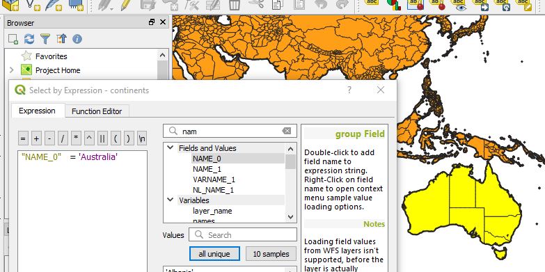
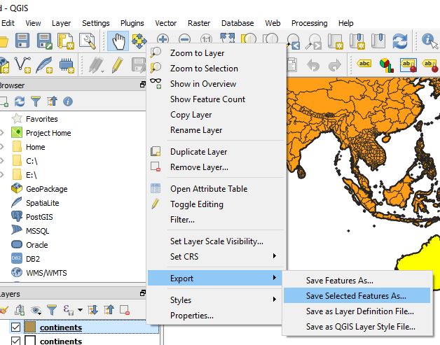
3.) Right click on the name of Shapefile layer Appearing in the Left upper side and select save as:
or
You can select layer from the menu, and click on save as. (Image below provide demonstrate both the options with the indicator displayed)
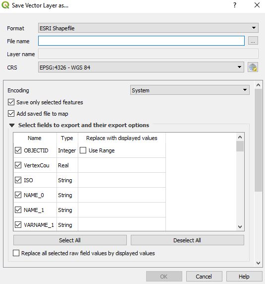
4.) In the Save vector layer as window, Select the format from the drop down box as Keyhole Markup Language(KML) and browse the folder in which you want to save the KML file . Name it and Press OK.
Your KML file will be Exported in the directed folder. You can Verify the generated KML file for its validity by uploading the generated KML file to QGIS or uploading KML file in Google map. You may soon find the tool and the coding for the same on this site.
You may check in converting Geojson to Topojson and Shapefile to TopoJSON file. Hope this may help you in converting Shapefile to KML file easily. If you still find problem in converting the file, do let me know by commenting below.
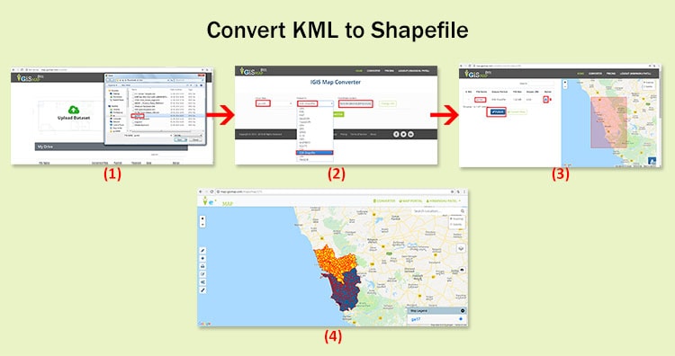
Convert KML to Shapefile in QGIS. KML or Keyhole markup language file which store and models geographic features for displaying in Google earth or Google maps, which is not common in use for Map makers and GIS programmers. ESRI made a standard Vector file i.e Shapefile which is most commonly adopted in the field of GIS (Geographic Information System), and this made me to convert KML to shapefile, created for learning purpose from Google map. QGIS (Qunatum GIS) is an open source GIS tool, which provide you a function to convert the KML file to Shapefile, and Vice versa i.e Shapefile to kml file.
You might be looking for converting KML to shapefile when you get the data from third party or from website which download free GIS map data but in different formats which can also be converted to.
1.) Open up the installed QGIS. 2.) Select Layer in the menu bar and press Add Vector Layer or select the shortcut icon. Browse the KML file, in the Source DataSet type, in the pop up window opened.(While browsing, select either all files or Key Hole Markup language in file type). And press Open.
Select the coordinate reference type system if coordinate reference window pop ups and press ok.
3.) In the Layer file appearing in the left upper side, right click on it, and select save as:
or
you can either select layer from the menu and click on save as.
4.) In the Save vector layer as window, Select the format from the drop down box as ESRI Shapefile(OGR) and browse the folder in which you want to save the shapefile. Name it and Press OK.
Your Shapefile i.e .shp, .shx and .dbf file will be created in the directed folder. Upload your KML file in your map browser tool, or try our tool, to verify whether the tool preserves all attributes and elements or not. You may also see how to merge two shapefile in QGIS. Or if you are looking to convert that shapefile to kml to Topojson then you can look for GeoJSON to Topojson and Shapefile to GeoJSON and shapefile to TopoJSON. Do comment below if you are getting any problem in converting the file.
This is what making it suitable to be used by a web application as an input. While layer file should be accurate with minimum error before deploying or issuing the same to the client, which requires lots of time to make. Obviously no client for project submission will tolerate the delay and so this task time is to be reduced. So this blog post will deal with, how reduce time duration of preparing a layer file?
This is quite possible by using ArcGIS inbuilt tools and this can be accomplished by understanding the need and using appropriate tool. A number of errors are generated at various stages of layer preparation like gap in a feature, overlap with other feature, self over and many more. These errors can be detected by selection tool or by running topology rules for every layer. But the question is removal of these errors. If there are just a hundred of polygons in layer one can remove it manually zooming on to every gap and overlap. But if there are a million or more number of polygons in a layer for example if a village has 1000 parcel on an average in a district of 600 villages, the total number of parcel in a district comes out to be 6 lakh. It takes almost equal time in preparing an error free file as much time used for preparing the layer file.
For this one task i.e. removal of gaps in a feature can be made easy and can be performed in less time by the use of a tool named Eliminate present in the Data Management toolset of ArcGIS.
Steps to remove gaps from a polygon layer file in ArcGIS
1.) First all gaps in a layer file should be converted to polygons using auto complete polygon tool from the editor bar.
2.) Then these polygons should be copied to layer file.
3.) Selecting all gaps in the form of polygon apply eliminate tool from data management toolset on the layer file.
4.) The gaps are merged with the neighboring polygon having larger area or longer shared border.
In this way the work of one month can be reduced to one week or lesser. This tool should be used for removal of small gaps only. As for larger gaps the decision of merging the gap polygon in which neighboring polygon should be done by visual interpretation and analytically perspective.
Hope this tutorial would help you to remove gaps from a layer file in ArcGIS. While I always works in Open Source tool in GIS, I would like to make you check the QGIS and QGIS tutorials.
If you are facing any problem related to the above, then do comment below, we would look for the problem and suggestion for the same.
We use cookies to ensure that we give you the best experience on our website. If you continue to use this site we will assume that you are happy with it.Ok