In this guide, we’ll walk you through how to efficiently convert your KMZ files to KML using the powerful Converter Tool in MAPOG Map Analysis. Whether you’re a beginner or an experienced user, Converting KMZ to KML with MAPOG, this tutorial will help you understand the process in easy steps.
Key Concept to Converting files
The Converter Tool is a feature in MAPOG Map Analysis that helps you change your data from one format to another. It’s like magic! You give it your data in one form, and it transforms it into another form that you need for your analysis. Additionally, with GIS Data, you can download data in any format, making it versatile and adaptable for various applications.
Online KMZ to KML Gis Converter
Now, let’s walk through the simple steps of using the Converter Tool to Converting KMZ to KML with MAPOG.
Step 1: Upload the Data
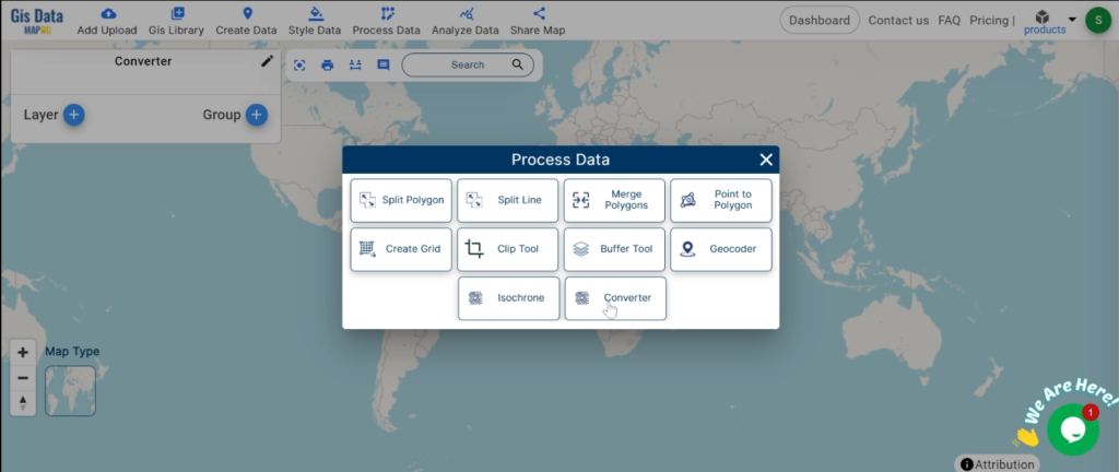
1. Click on the “Process Data” menu and choose the “Converter Tool” option.
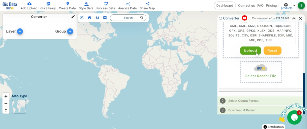
Upload your KMZ file. This is your starting point where you provide the data that needs conversion.
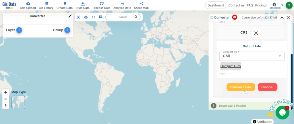
Step 2: Select the Format for Conversion
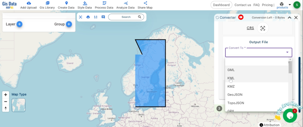
Choose the output file format as KML. The tool offers various formats, but for this guide, we are focusing on converting to KML.
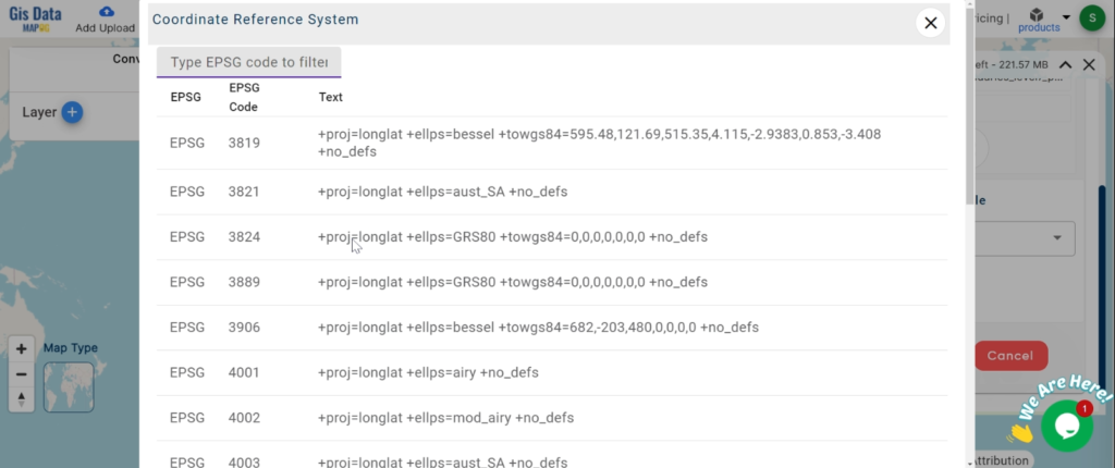
2.You can also set the CRS at this stage.
Step 3: Run the Conversion
Click ‘Convert’ and let the tool work its magic. The Converter Tool processes your data, transforming it from KMZ to KML format.
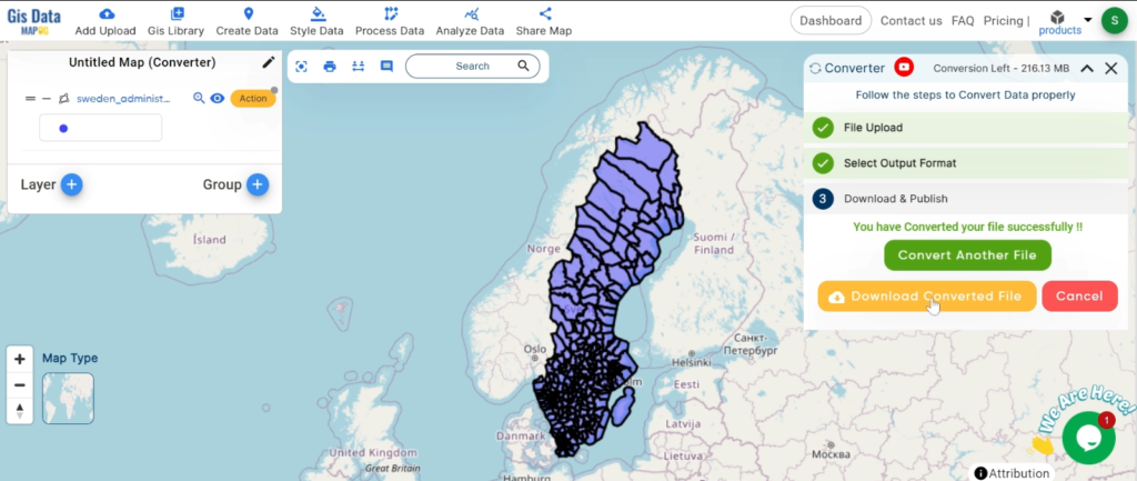
Step 4: Review and Download
Finally, review your converted KML data to ensure it looks right. Once satisfied, download the converted file. This step is crucial to verify that the conversion has been successful and the data integrity is maintained.
And there you have it! You’ve successfully used the Converter Tool in MAPOG Map Analysis to convert your KMZ files to KML. Now you can easily convert your data for all your analysis needs. This feature simplifies the process of handling different data formats, making your workflow more efficient and effective.
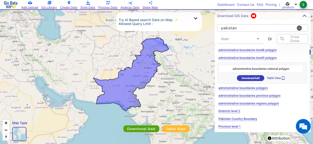
Unlock a world of geospatial insights with MAPOG, your gateway to Download Pakistan Administrative Boundary GIS Data for– National, Province, Districts and more. Dive into a treasure trove of datasets covering national, provincial, district levels, and more.
Navigating Pakistan’s GIS data is seamless with MAPOG. Access over 200 meticulously curated datasets to detailing administrative boundaries and geographic features such as rivers, roads, and national parks. Our platform offers intuitive tools for effortless exploration: Download Pakistan Administrative Boundary GIS Data for– National, Province, Districts and more. With the Download GIS Data tool, choose from a variety of formats like Shapefile, KML, GeoJSON, or CSV to obtain the precise data you need. Need guidance on using the Add GIS Data tool? Consult our comprehensive guide for step-by-step instructions. Let MAPOG be your trusted companion on an enriching geospatial journey through Pakistan’s breathtaking landscapes.
Our platform supports an extensive range of data formats, including KML, SHP, CSV, GeoJSON, Tab, SQL, Tiff, GML, KMZ, GPKZ, SQLITE, Dxf, MIF, TOPOJSON, XLSX, GPX, ODS, MID, and GPS, ensuring seamless compatibility and accessibility across different analyses.
Note:
all data provided by MAPOG are in GCS datum EPSG:4326 WGS84 CRS (Coordinate Reference System).
Additionally, access to shapefile downloads requires logging in to the platform.
Download Pakistan Administrative Boundary- National
Pakistan, nestled in South Asia, offers a captivating blend of natural beauty and cultural heritage. Bordered by India, China, Afghanistan, and Iran, it boasts diverse landscapes ranging from the towering peaks of the Karakoram and Himalayas to the vast deserts of Sindh and Balochistan. The country’s rich geography includes iconic landmarks such as K2, the second-highest mountain in the world, the ancient city of Mohenjo-Daro, and the bustling metropolis of Karachi.
Download Pakistan Administrative Boundary- provinces
Pakistan is divided into four provinces and two autonomous territories, each encompassing a unique blend of cultural, geographical, and historical significance. These regions play a vital role in decentralized governance and regional development efforts. Delve into the administrative boundaries and geographic features of Pakistan’s provinces and territories to gain a deeper understanding of their diversity and importance. Here are Pakistan’s provinces and territories:
Pakistan is divided into 154 districts, each encapsulating a unique blend of cultural heritage, geographical features, and administrative significance. These districts serve as fundamental units of governance and are essential for regional development efforts. Delve into the administrative boundaries and geographic features of Pakistan’s districts to gain a deeper understanding of their diversity and importance.
Disclaimer : If you find any shapefile data of country provided is incorrect do contact us or comment below, so that we will correct the same in our system as well we will try to correct the same in openstreetmap.
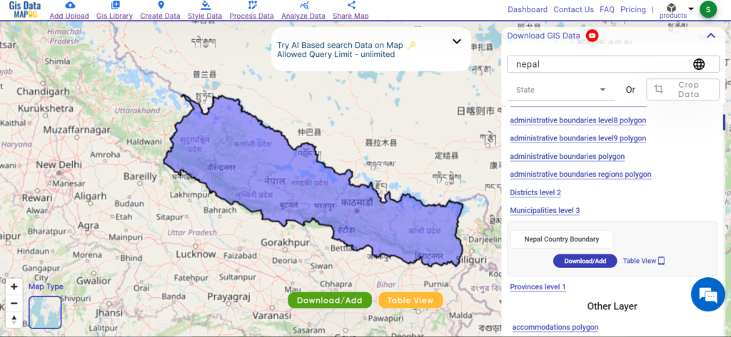
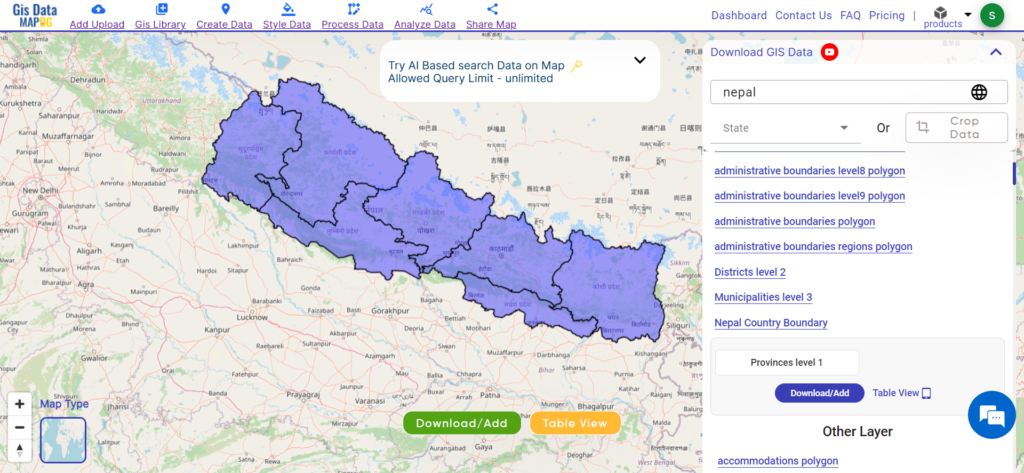
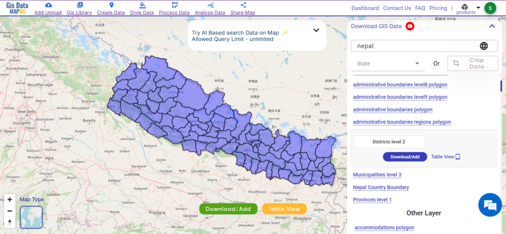
Unlock Nepal’s administrative landscape with MEPOG! Access district-level GIS data for informed decision-making and strategic planning.
Unlock a world of geospatial insights with MAPOG, your gateway to Nepal’s administrative boundary GIS data. Dive into a treasure trove of datasets covering national, Province, Districts and more.
Navigating Nepal’s GIS data is seamless with MAPOG. Access over 150 meticulously curated datasets detailing administrative boundaries and geographic features such as rivers, roads, and national parks. Our platform offers intuitive tools for effortless exploration: Download GIS Data and Add GIS Data. With the Download GIS Data tool, choose from a variety of formats like Shapefile, KML, GeoJSON, or CSV to obtain the precise data you need. Need guidance on using the Add GIS Data tool? Consult our comprehensive guide for step-by-step instructions. Let MAPOG be your trusted companion on an enriching geospatial journey through Nepal’s breathtaking landscapes.
Our platform supports an extensive range of data formats, including KML, SHP, CSV, GeoJSON, Tab, SQL, Tiff, GML, KMZ, GPKZ, SQLITE, Dxf, MIF, TOPOJSON, XLSX, GPX, ODS, MID, and GPS, ensuring seamless compatibility and accessibility across different analyses.
Note:
all data provided by MAPOG are in GCS datum EPSG:4326 WGS84 CRS (Coordinate Reference System).
Additionally, access to shapefile downloads requires logging in to the platform.
Download Data of Nepal
Nepal, nestled in the heart of the Himalayas, offers a captivating blend of natural beauty and cultural heritage. Bordered by India and China, it boasts diverse landscapes ranging from the majestic peaks of the Himalayas to the lush valleys of the Terai region. The country’s rich geography includes iconic landmarks such as Mount Everest, the birthplace of Lord Buddha in Lumbini and the medieval city of Kathmandu.
Nepal is divided into seven provinces, each encompassing a unique blend of cultural, geographical, and historical significance. These provinces play a vital role in decentralized governance and regional development efforts. Delve into the administrative boundaries and geographic features of Nepal’s provinces to gain a deeper understanding of their diversity and importance. Here are Nepal’s seven provinces:
Nepal is divided into 77 districts, each encapsulating a unique blend of cultural heritage, geographical features, and administrative significance. These districts serve as fundamental units of governance and are essential for regional development efforts. Delve into the administrative boundaries and geographic features of Nepal’s districts to gain a deeper understanding of their diversity and importance.
Disclaimer : If you find any shapefile data of country provided is incorrect do contact us or comment below, so that we will correct the same in our system as well we will try to correct the same in openstreetmap.
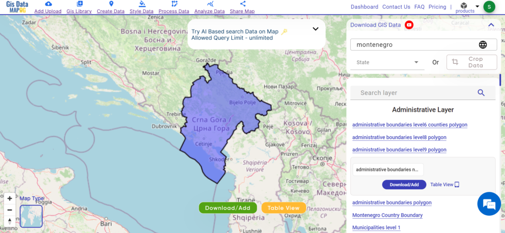
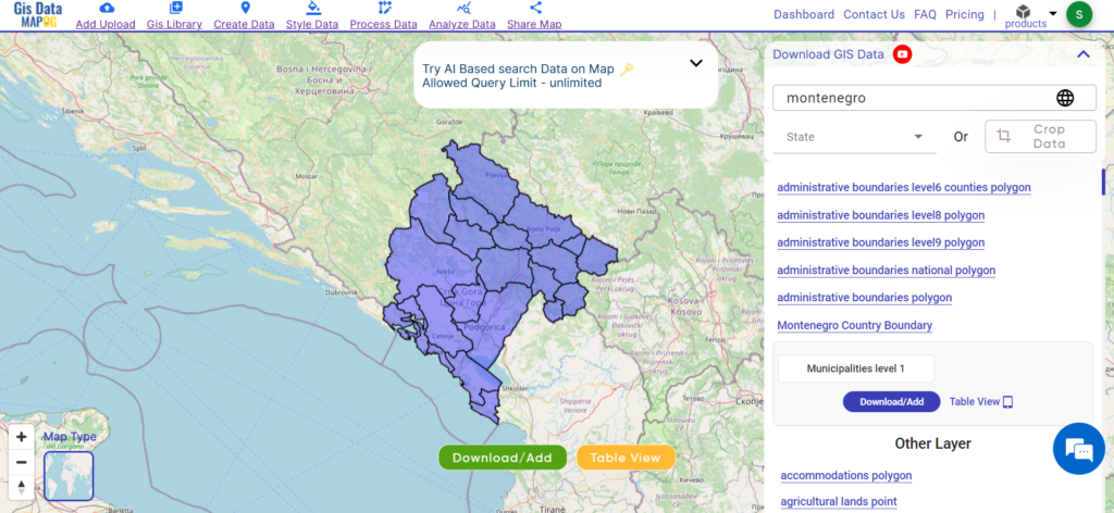
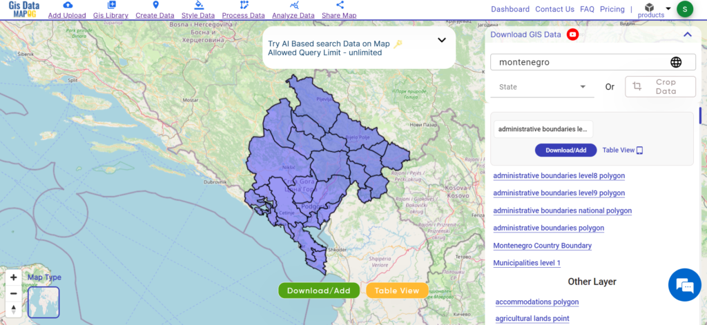
Access Montenegro’s GIS data effortlessly with MAPOG! Explore administrative boundaries, rivers, roads, and more for comprehensive insights.
Embark on a journey of endless possibilities with MAPOG! Gain exclusive access to Download Montenegro Administrative Boundary GIS Data for – National, Municipalities, Regions and others layers.
Exploring GIS data for Montenegro is effortless with MAPOG. Dive into a diverse collection of over 150 datasets meticulously detailing administrative boundaries and geographic features such as rivers, roads, and airports. Our platform offers two integrated tools for seamless navigation: Download GIS Data and Add GIS Data. With the Download GIS Data tool, choose from a range of formats like Shapefile, KML, GeoJSON, or CSV to effortlessly acquire the precise data you need. If you seek to enhance your understanding of the Add GIS Data tool, refer to our comprehensive guide. This guide walks you through the process of obtaining administrative-level GIS data using the Download GIS Data tool. Let MAPOG be your trusted companion on an enriching geospatial journey through Montenegro’s stunning landscapes.
Our platform supports an extensive range of data formats, including KML, SHP, CSV, GeoJSON, Tab, SQL, Tiff, GML, KMZ, GPKZ, SQLITE, Dxf, MIF, TOPOJSON, XLSX, GPX, ODS, MID, and GPS, ensuring seamless compatibility and accessibility across different analyses.
Note:
all data provided by MAPOG are in GCS datum EPSG:4326 WGS84 CRS (Coordinate Reference System).
Additionally, access to shapefile downloads requires logging in to the platform.
Download Data of Montenegro
Montenegro, situated in southeastern Europe on the Balkan Peninsula, offers a captivating blend of stunning landscapes and rich cultural heritage. Bordered by Croatia, Bosnia and Herzegovina, Serbia, Kosovo, and Albania, it boasts picturesque coastlines along the Adriatic Sea and rugged mountains inland. The country’s diverse geography includes the dramatic peaks of Durmitor National Park, the serene waters of Lake Skadar, and the historic charm of coastal towns like Kotor and Budva.
Montenegro is divided into municipalities, each serving as an administrative region within the country. Montenegro comprises 23 municipalities, each contributing to local governance and development. Here they are:
In Montenegro, regions serve as smaller administrative units within municipalities, playing a crucial role in local governance and service delivery. These regions facilitate direct interaction between the government and communities, enhancing efficiency in development efforts and public services. With a total of 64 regions across the country, Montenegro ensures decentralised administration and targeted interventions tailored to the specific needs of local communities.
Disclaimer : If you find any shapefile data of country provided is incorrect do contact us or comment below, so that we will correct the same in our system as well we will try to correct the same in openstreetmap.
Loading Comments...
We use cookies to ensure that we give you the best experience on our website. If you continue to use this site we will assume that you are happy with it.Ok