Convert Shapefile to kml by QGIS. Shapefile is ESRI based Vector file, While KML or Keyhole Markup Language is file which models and stores geographic features for display in Google Earth or Google maps. Many times you may require to convert the required shapefile to KML file, so that you can deploy the same over Google Earth for some reason. QGIS (Quantum GIS) is an open source GIS (Geographic Information System) tool, which let you upload the Shapefile and convert the same to KML file. Similarly ogr2ogr is also an open source tool, which let you to convert between GIS data formats. Look over shp to kml convert using ogr2ogr tool which can be marked as an alternative to this article. You can also see to convert Kml to Shapefile and also Shapefile to GeoJSON in QGIS.
You can also try Online conversion instead of QGIS MAPOG Online converter tool
You can also go through other tutorial in QGIS.
Free SHP to KML conversion using GIS Converter Tool in one click.
Here are the steps to convert shapefile to kml:
Convert Shapefile to kml in QGIS

Convert Shapefile to kml in QGIS:
1.) Open up the installed QGIS.
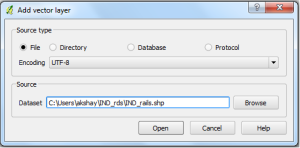
2.) In the menu bar, select Layer and press Add Vector Layer. Now select the source type in the pop up window opened as File and browse the source Shapefile(Note:Your shapefile .shp, .dbf and .shx file should be in same folder). Press open.

Select the coordinate reference type system if coordinate reference window appears and press ok.
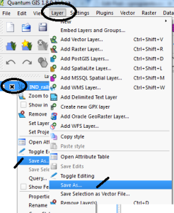
3.) Right click on the name of Shapefile layer Appearing in the Left upper side and select save as:
or
You can select layer from the menu, and click on save as. (Image below provide demonstrate both the options with the indicator displayed)

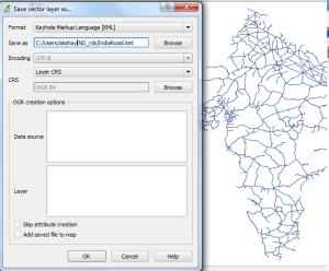
4.) In the Save vector layer as window, Select the format from the drop down box as Keyhole Markup Language(KML) and browse the folder in which you want to save the KML file . Name it and Press OK.

Your KML file will be Exported in the directed folder. You can Verify the generated KML file for its validity by uploading the generated KML file to QGIS or uploading KML file in Google map. You may soon find the tool and the coding for the same on this site.
You may check in converting Geojson to Topojson and Shapefile to TopoJSON file. Hope this may help you in converting Shapefile to KML file easily. If you still find problem in converting the file, do let me know by commenting below.

Is it possible to export to KML with a persol style added to the layer, for exemple, with colors according with population density, generated by QGis?
exported to KML/KMZ.
It can be helpful to note that there are two fields in the exported KML file that can be used to store metadate e.g. names or numbers to enable the shapefile to be linked to other datasets these are Name and Description. This is useful for when you are creating KML files for use in tools such as Qlik Sense.
Steps:
1. Right click on your layer and select Open Attribute Table
2. Note down the names of the fields that contain the metadata you want to bring across
3. Update the DescriptionField and NameField boxes in the “Datasource Options” with the metadata field names.
Thank you Rean for the information.
Thanks for this information.
However, it seems not to work if the type of one of those fields is numeric.
Do you have an idea ?
Sorry, it works great.
Thanks
I can manage to convert from shp to kml but some of the tribute table s missing. Why is it like this? and how can I simply convetr Shp to KML together with the atribute table.
Thanks
Q Gis 2.8
How to convert Point,Line,Polygon at time create a one kmz file.
Thanks for such an interesting post you share with us. It’s really helpful for us. I am very thankful for you and your post.
Yoy can also use Simptagger 1.1 tool to create Shape file to KML File.
Eu gostaria de transformar um arquivo SHX para KML mas não encontrei nenhum aplicativo ou plataforma alguém saberia me informar se tem algum app que faça isso alem do autocad e do arcgis desktop?
You can use online tool : https://map.igismap.com/converter
Hi Akshay,
I’m struggling to convert a shapefile to kml. The original shapefile is in epsg 3035 and I cannot for the life of me convert the projection CRS into a wgs 84 format to export as a kml file to use in Google Earth? Tried converting to ESRI:54030 – World_Robinson but sadly no joy. Message generated ‘Export to vector file failed.
Error: Creation of data source failed (OGR error: Failed to create KML file Natura_2000.kml: Natura_2000.kml: Read-only file system)’.
What am I doing wrong? Any suggestions would be much appreciated.
The GIS data I am attempting to convert can be downloaded from the website (https://www.eea.europa.eu/data-and-maps/data/natura-14). Natura 2000 End 2021 – Shapefile.